[beforeafter]
 [/beforeafter]
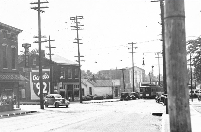
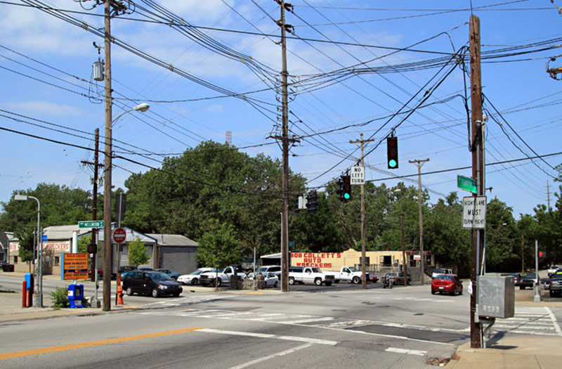
Welcome to the Friday News Roundup, our editors’ top ten picks for must-read news throughout the week. As with all news roundups, we play the street scene guessing game. Let’s start with the fairly easy special-edition before and after above. That intersection has changed quite a bit in a hundred years, and now features parking lots on all four corners. (Do you need another reason to get to ReSurfaced?) Tell us where it is in the comments.
- Should Cities be Built to Make People Happy? This Big City makes the case for the benefits of urban social connection over economic wealth as a factor in mental health. (This Big City)
- Transforming In-Between Spaces for the Benefit of Urban Communities. This Big City takes a look at what’s being done with “in-between” spaces in cities. How can they be activated to connect communities? (This Big City)
- Sheppard Square Project Gets $31,000 Grant for LEED Certification. Mixed income housing goes “super green” at Sheppard Square. (WFPL)
- The UN Climate Summit: What’s in it for Cities? Sustainable Cities Collective takes a look at the responsibility of cities in the upcoming UN climate summit. (Sustainable Cities Collective)
- New Family Health Centers facility on East Broadway will offer affordable health care in many languages. A new family health center in the old American Standard (Louisville Antique Mall) building looks to improve the community’s access to “sensible, efficient, and compassionate” preventative health care. (Insider Louisville)
- “Cards Against Urbanity” is exactly as hilarious as you’d expect. Urbanism’s cool factor is secured through this card game. Thanks, Richard Florida! (Elevation DC)
- This new market might make downtown Louisville green with envy. Louisville’s ever-allusive downtown grocery is soon to be a reality in New Albany! (Business First)
- How Cities Will Feed Their Citizens in the Future. Can urban gardens make the leap to urban agriculture? The Vertical Farming and Urban Agriculture conference held at Nottingham University argued that we options are available if we have the will to implement them. (Sustainable Cities Collective)
- Top 10 Websites – 2014. Love maps? Love data? Love cities? This is the top ten list you’ve been waiting for all year! (Planetizen)
- The Challenges Of Talking About Quality of Place In a Small Town. Aaron Renn discusses how small town quality comes from small town people. But what does that mean for the realization of larger scale urban developments and quality of life improvements in those spaces? (Urbanophile)
[Images: Modern photo by Diane Deaton Street; Historic view courtesy UL Photographic Archives / Reference.]


The intersection in the photos is Frankfort and Mellwood, looking west towards Mellwood and Story.
One thing overlooked this week is the fact that TIGER grants were announced this week:
http://t4america.org/maps-tools/tigermap/
Looking at the interactive map, you can see that the closest project to Louisville is replacing 19th century railroad bridges over the Ohio in Muldraugh. Indy on the other hand won three grants to start working on electric BRT, and bike and pedestrian networks, Cincinnati got money for designing the next phase of their street car system, and Nashville also received cash for their BRT.
Meanwhile, Louisville has finally settled on an operating entity for tolling drivers to pay the billions in unneeded highways and bridges that we’re tearing up half the city for to ram through our downtown.
To clarify: isn’t the before picture looking west and the after picture looking east? I don’t think these are a match.
@Jeff Cavanaugh –
@Steven Ward – The large warehouse in the back of the historic image is what’s now Hadley Pottery, which would be in that same location in the modern view behind the trees if you followed down Frankfort and turned left onto Story Avenue. Or am I seeing the angle incorrectly?
Oh, how I’m glad Broken Sidewalk is back! That’s definitely Hadley, though at one point there could have been additional outbuildings (could have been a textile factory?) around or attached.
Don’t confuse this for a glass-half-full, yea-progress! comment at all, but in light of the tree canopy deficit, the new photo definitely has more. ‘Course the streetcar and density more than make up for the (since photo, possibly better?) bad intersection for bikes/one-way urban expressway. And, I suppose those unkempt trees in the (overlooked!) Beargrass basin shield the worst (I-64) from view in the modern pic.
Sorry, I missed your response, Brandon. It was the Hadley Pottery building I was seeing that triggered my comment, but I was a little off in my description:
It looks like the historic view is looking at the southwest corner of the intersection of Story/Frankfort, with Hadley off farther to the southwest. The modern view is looking to the northwest corner of the intersection of Mellwood/Frankfort to Collett. So Hadley might be behind those trees, but the view would be different, i.e. none of the same structures would/could be visible in these photos.
Jeremy’s comment re: tree canopy comparison may be skewed by this. Behind Collett may be similarly treed now as then because Beargrass Creek runs north of Collett’s, while the space between Frankfort and Hadley looks very different. If you point your Google maps to Sergio’s World Beers and look back at Hadley you get the best view of the change.
Ah, I am with you now Steven. I think you’re right in the fact that these are two different (albeit close) intersections. The gable angle on the Hadley roof and the building on the SE corner of Frankfort/Story (far left of the old picture) made the case for me. That right-turning car in the old pic would be a major no-no today!@Steven Ward –
Hmmm, I took the modern photo. I could be wrong but I felt pretty certain that the gable angle on the Hadley buidling would be correct here. It is pretty hard to believe it’s the same intersection. Here’s a link to the historic photo at the U of L archives:
Frankfort Avenue, Louisville, Kentucky, 1935.
The description states the intersection is Frankfort and Mellwood.
See also bird’s eye view.
Check out the maps on the Mellwood Bourbon article, specifically, this one. It shows two buildings very similar to these two above framing the view south on Mellwood. Essentially, that car above is turning from Mellwood onto Frankfort heading away from the river.
Here’s another view from the opposite direction, showing the view up Frankfort Avenue from the bridge over Beargrass Creek, with the two buildings in question on the right.
@Branden Klayko – Okay, we all know pretty well what we’re talking about here–that’s obvious. Hell, Diane took the picture! 🙂 But it is difficult to ‘talk’ about angles and such in words (at least a little for me).
If you pan around a little on this streetview (sorry if it isn’t hyperlinked):
http://goo.gl/maps/Xs5er
I am thinking that 1602 Story matches the building in the far left edge of the original old, photo post. But that’s not to say that a similarly constructed business could not have been on the SW corner of Frankfort/Mellwood.
Plus, from the Bing bird’s eye, the pitch of Hadley’s roof would starkest from roughly due east (i.e. Frankfort & Story) rather than further south at Frankfort & Mellwood.
I own a house in the 1500 block of Story, hence the excessive interest!