Well, after yesterday’s release of KYTC’s kinda-sorta study of the 8664.org proposal, we wanted to take a closer look at what is actually planned for construction in the $4.1 Billion Bridges Project. Sure, it won’t be pretty to have an even larger highway covering Waterfront Park, and yes Butchertown is in grave danger with a 23-lane interchange sitting on its shoulder, but one of the most destructive portions of the project has garnered the least attention: widening Interstate 65 from the Hospital Curve to Spaghetti Junction.
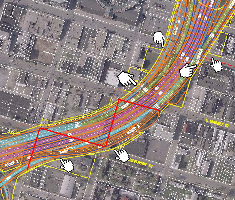
All maps in this article come from the KY/IN Bridges Project, we added pointers and lines for emphasis. The diagram above shows the widened 12-lane Interstate 65 slicing through downtown (it’s currently 7 lanes). That 12-lane highway gets really big when considering a highway lane is on average 14–15 feet wide and a modern shoulder is 10 feet. The red line shows one scenario where a pedestrian could walk four entire blocks and never see the light of day. You will be under the highway the full extent of the journey.
Then there’s the issue of the physical space a 12-laner takes up in a city’s central core. Many buildings will be torn down for the project and many oddly sized, triangular parcels will be created that can’t effectively be developed into the uses a vibrant downtown needs. (Who wants to look out their new condo at 12-lanes of semis?) Many of the future-demos include historic structures like the Baer Fabrics Building, a small red brick 1880s building, a century old ice warehouse, part of the century-old Vermont American factory, and others. Maybe worse than demolition, the Billy Goat Strut apartments on Main Street and Hancock Street, one of the first redevelopment projects in town with some of the best historic architecture, will have a great view of the highway, what appears about 15 or 20 feet from its windows. Most of those pointers indicate historic properties in the way of the highway.
The bottom pointer on the top map shows an interesting feature of the highway: a double decker road that could be as tall as a six-story building as ramps weave together to avoid merging for cars. And where does this one occur? Across the street from the new Liberty Green mixed-use, mixed-income neighborhood. The highway here will dwarf the 3–4 story new construction being built by the city and private developers. It also takes a lot of property from Wayside Mission, too.
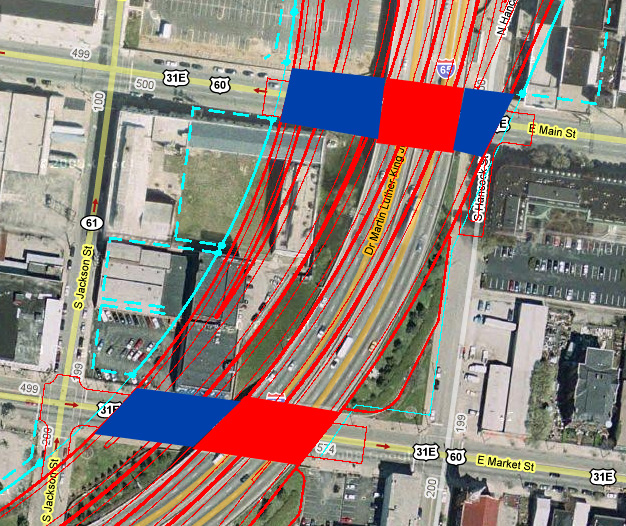
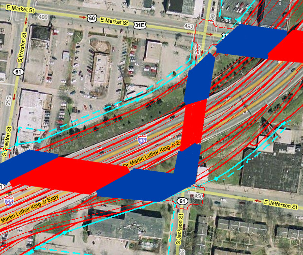
It’s sometimes difficult to comprehend the size of the new road without seeing the current Interstate 65 alongside it. The maps above and below show just how much wider the highway will be through downtown Louisville: doubled in size. The solid red areas show the current highway crossing the street and the blue areas show the additional street coverage with the new highway. It becomes more than twice as wide covering Main Street. Try going down under the Interstate 65 overpasses sometime and just look around at the wonderful patina of the rusting steel and flaking paint and the beautiful clanging orchestra of semi’s passing overhead. Smells great too. And don’t forget, lest some of our politicians remind us, elevated highways make excellent umbrellas. Then try to imagine twice as much concrete and steel covering the road and how much better downtown will be.
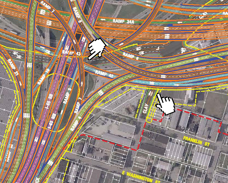
Above, we see Interstate 65 spreading its wings and joining Spaghetti Junction. The two pointers indicate another unique feature of the project, a feat rarely seen outside of the Interstate system in California: a 4-stack road. That means there’s a road on the ground where the pedestrian roams and three levels of highway directly on top of you. With modern height clearances, these 4-stack points in the Junction could be pushing 75 or 80 feet tall or more. There’s a small grey patch between the orange and green in the upper right corner. That’s the surface intersection of Witherspoon Street and Clay Street. The intersection is completely enclosed by the junction. Imagine taking in some River City scenes with 60 feet of concrete on all sides of you.
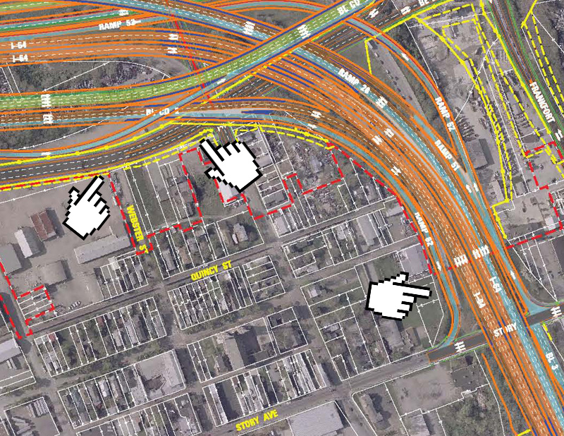
Above is the view of the eastern end of Spaghetti Junction as Interstate 64 makes its way in. You may know that the current Interstate 64 is four lanes when it crosses Story Avenue. It’s unpleasant but no sweat when walking under it today. There’s even a nice Butchertown mural to look at. Get out your paints, it time to expand that mural. That four-lane overpass has suddenly become an 8-9 lane overpass with broader shoulders. This area of the junction has several three-stack roads as indicated by the middle pointer. The new Witherspoon extension pushing through to Frankfort was designed for cars. We haven’t heard of any bike lanes on the new street. It doesn’t tie into the Butchertown grid, either. This map shows Webster Street terminating in a dead-end at the new parkway (left pointer). The intersection of Witherspoon and Adams is covered by highway, too.
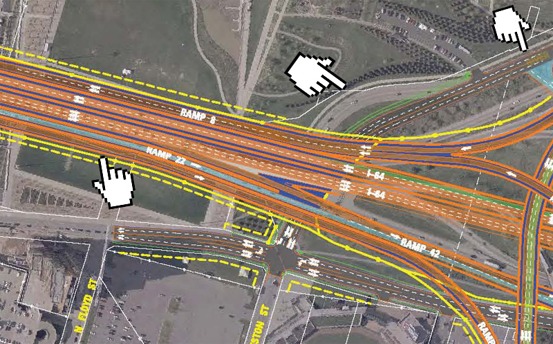
Finally, this analysis wouldn’t be complete without a look at Interstate 64 over Waterfront Park. You’ve already heard all sorts of horror stories about how the highway will tear the park to shreds. We’ll add one more point. Notice the middle pointer. You can see the existing River Road and a straightened out, less curvy one the state wants to build. This will increase car travel speeds around this bend and, you guessed it, the park will suddenly be a little more dangerous to walk along.
While the community might know there are two bridges and a new junction under the state plan, no one seems to be talking about the actual design and implications it has on downtown and its surrounding neighborhoods. Hopefully, seeing the actual damage done by the state’s proposal will get a conversation going as to whether this tangle of concrete is actually good for downtown. While these plans and maps are likely to change here and there are the designs are finalized, it won’t get much better than this. Oh, you thought we were done? We thought you might like to know what that really expensive tunnel planned for the East End Bridge is all about, too. More on that after the click.
- 8664.org (Official Site)
- KY/IN Ohio River Bridges Project (Official Site)
- 8664 Study Released & Fighting That East End Bridge (Broken Sidewalk)
- Uncertain Fate of Baer Fabrics Building (Broken Sidewalk)
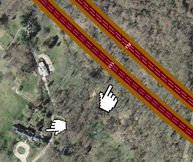
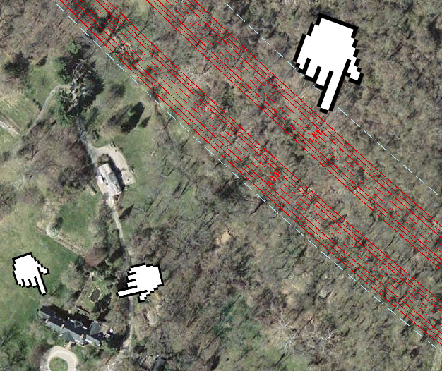
We’ll be brief here, this topic opens a huge can of worms, but these maps are interesting. We’ve heard all about how we need to protect the historic Drumanard Estate of U.S. 42 because it’s on the National Register of Historic Places (built in the 1920s, we think?) and its gardens were designed by the Olmsted firm, and its so pretty out there. Have you seen the house? We haven’t either. It sits well off Wolf Pen Branch Road behind a long and winding driveway.
It turns out, the new highway won’t even come close to the house or its gardens, or even its guest house.
These diagrams each point to the highway tunnel and the house. As you can see, it’s pretty wooded up there. We’re spending hundreds of millions of dollars to save some woods. These woods were not designed by Frederick Law Olmsted. They are not on the National Register. They are woods. While it would be fun to have a tunnel (we love tunnels!), is it worth it to sacrifice downtown with that portion of the project and save some woods on this portion? The entire Bridges Project is a little screwy, if you ask us.



I hope we can beat this!
So the east end bridge would allow thousands of travelers to see the house and garden daily? I think that’s the best thing to do for something on the national registry: make it visible!
[…] you care about or love Louisville even one ounce, you should read this article and consider what might become of it. Broken […]
Wow.
BTW: A standard highway lane is 12 feet wide.
Great post! As I work in one of the buildings slated for demolition should this monstrosity ever be built, it does seem like very few people are concerned with how such demos will affect the neighborhood (esp. when we’re talking about century-old buildings).
One quibble though: woods are worth saving! Especially in the area around US 42. Over the years development on 42 and US 22 have destroyed tons of otherwise-fine forest. The East End is just as much a victim of poor planning as downtown, in my opinion.
But Joel, at least the infrastructure and grid are there in downtown. The east end should have stayed rural. Both are victims of poor planing, but the original structures and planing of the city center are golden compared to the current state of that area of the east end.
Right, and yet the two-bridge plan doesn’t seem to be an enhancement on downtown’s “infrastructure and grid,” as we can see from this post.
As a Hoosier, it is clear that all things about Indiana are regarded by most Louisvillians as second rate; the people, the perceived culture, etc.. I suspect the resistance against an east end bridge has a lot to do with the fact that Indiana stands to benefit more financially than Kentucky. That, and the huge money in the east end. At this point, there’s no “fixing” the circuit of travel that has already been built, so complete it.
I think the 8664 plan is the best proposal so far, especially considering this new information. I don’t think it’s fair to sacrifice several dense city blocks with great potential, for some woods in the east end. That was the intent of my comment. The city is more important to preserve than the woods. Build the highway in the woods for interstate traffic. Keep the local traffic on the grid. Or better yet eliminate more local traffic with public transit.
We never meant to imply woods weren’t worth saving. It’s just interesting there has so much discussion of historic preservation when it comes to the 1920s era Drumanard Estate which doesn’t appear to come remotely close to the highway ROW, but there’s no concern for destroying 1880s era buildings and the city grid downtown. Tunnel or no tunnel, it all comes down to a need for an East End Bridge immediately.
The East End bridge should be built immediately, and without the tunnels. And then this project should stop there for the time being. It is so important to the economic development of the region. Sure, IN would gain the physical attributes as far as development is concerned. But, give the large tracts of land available at the old ammunition facilities, it would open up the region to a myriad of development. The downtown interstates should be left alone. Although I-64 doesn’t look great, neither would a parkway going through Waterfront Park. Any further west is nothing but flood plain, and that area would be largely unused because of it. I also don’t care what the plans for Spaghetti Junction are, you are not going to move cars through seamlessly where 3 interstates intersect. They should leave what is there, because nothing will make it better (other than less cars). Our best hope for reducing traffic (for now) is an East End Bridge. Future plans should include more accessible and efficient public transit, and a southwestern bridge connecting Valley Station to Elizabeth, IN, on upto I-64.
I’ve been hearing your recent radio commercials for 8664.org on WHAS.
Your commercials featuring the voice of a young girl saying “I don’t want to go to interchange Hell” has caused me to write this post in disgust of your organization’s marketing tactics.
I think those commercials are what I’ll remember most about your organization – how ironically childish of you.
The commercials of which you speak are not affiliated with Broken Sidewalk. We haven’t heard the commercials yet, so we’re going to withhold judgement at this point. We support 8664.org but are not officially affiliated with the organization.
I just reviewed the graphic presentation of how century – old buildings will be affected by the Ohio River bridges Project in Butchertown, not to mention if I-65 gets widened as well. It is pretty disturbing. I am also not against disturbing forests, but this is one case where definitely it is the lesser of the two evils! Build the East end bridge without tolls! Only then will we know if the downtown bridge is necessary. Can everyone please just write one letter to one elected official. The budget committee is about to pass a tolling authority in both the House and the Senate in Frankfort. Once this happens, we will lose any opportunities for local input in this project.
[…] means the widening of the I-65 approach through the hospital curve. Our friends at Broken Sidewalk put together fabulous coverage of this. Here’s a rendering they pulled from the bridges project […]
“Although I-64 doesn’t look great,” Actually I-64 looks terrible and a well landscaped waterfront boulevard can be attractive while moving large amounts of cars. Think pedestrian overpasses, landscaped median, metal pedestrian railings, limited stops, turning lanes, and a continuous great lawn. In my opinion the Ohio River Bridges Project will go down as one of, if the not the biggest urban planning mistakes of the 21st century. Personally I don’t plan on sticking around to see Louisville locked into a future of mediocrity if this thing is constructed.
4 Billion and you still won’t be able to go from I-64 West to 71 North or 71 South to 64 East. Does anyone else know of an intersection of two Interstates where you can’t go from one to the other?
[…] means the widening of the I-65 approach through the hospital curve. Our friends at Broken Sidewalk put together fabulous coverage of this. Here’s a rendering they pulled from the bridges project […]
[…] means the widening of the I-65 approach through the hospital curve. Our friends at Broken Sidewalk put together fabulous coverage of this. Here’s a rendering they pulled from the bridges project […]
This is horrendous, i don’t understand why were doing this,is so obviously a mistake and dated.