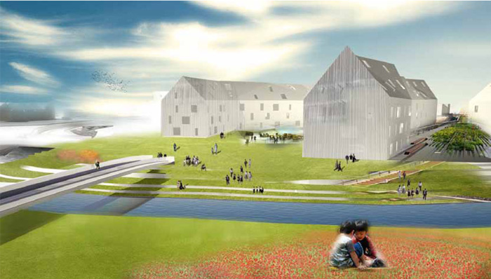
We’re big fans of design competitions here at Broken Sidewalk and Irish Hill’s Mediative Urbanisms competition last year has generated some of the most creative ideas for an infill brownfield site in recent memory. I’m going to take a closer look at a few of the design proposals from several projects here, but I really recommend checking out the entire exhibit of all 20 entries from around the world at the Urban Design Studio on 3rd Street. Your last chance to see it in person is this Friday at the Trolley Hop, so mark it on your calendar now.
Needless to say, there were countless good ideas that came from the Mediative Urbanisms design competition. To catch up on the competition, you might want to check out previous Broken Sidewalk coverage here and here and here. You’ll also want to stop by the Irish Hill Neighborhood Association page as well to see every project board from the competition.
Below are my observations from the entries. Each proposal brought unique ideas to the table and I won’t have time to discuss them all here, but let’s try to tackle some major points. Please feel free to share your observations and agree or disagree in the comments below.
Development Intensity
Each project proposed to build out the 30-acre brownfield site on Lexington Road slightly differently. The winning entries seem to have left generous amounts of green space while many others opted for increased density, filling the site with more buildings, and a few covered the entire area with buildings.
While these proposals aren’t meant to be built—only generate ideas for future development—it’s important to view them as balancing the environmental needs of the site (i.e. a protected Beargrass Creek watershed and increased park space) with the development needs of building a large mixed-use urban project (ability to turn a profit) among others.
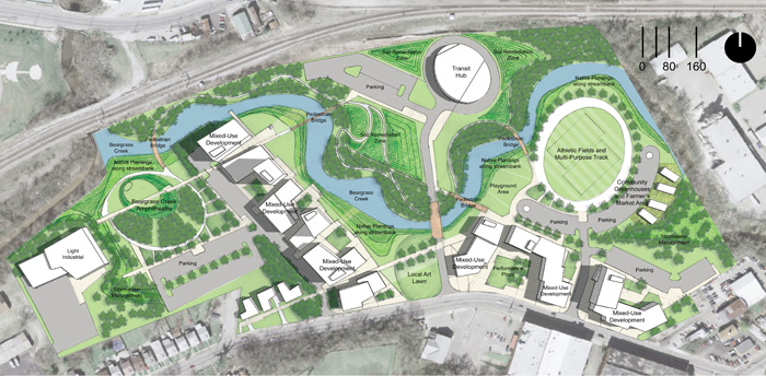
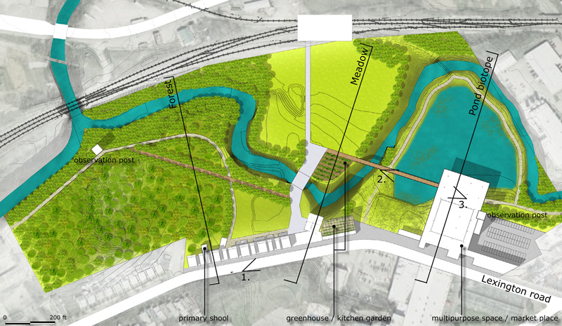
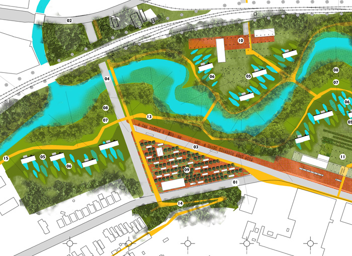
In my opinion, a certain level of density is also going to be important to foster a real town center feel for Irish Hill given the central location of the site. Above and below are examples of a higher density and lower density plan respectively. The plan below ended up winning first prize in the competition.
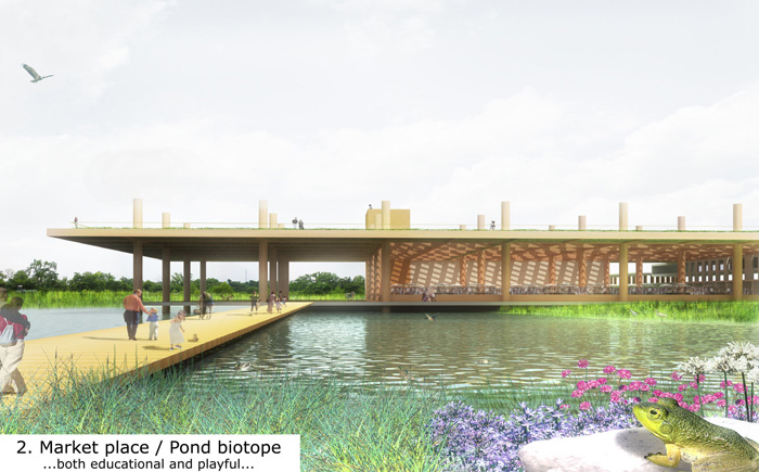
The Scenic Walkway project (below) provides some delightful poetry in its layout, pairing different uses with unique landscapes: a school with the forest, greenhouses and housing with the meadow, and a covered market with a biotope pond (a shallow pond to provide habitat and deal with stormwater). Development is pushed to Lexington Road and the rest of the site is left as undeveloped or parkland. A total of 60 new residences are proposed.
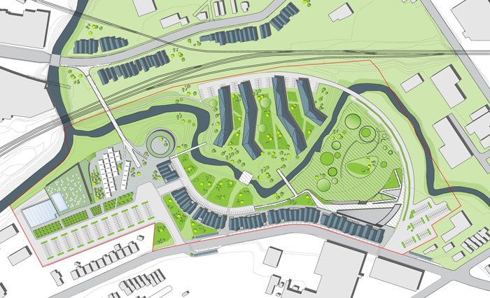
Above, Patchwork Green (above) creates more of an urban center, pulling development and activity into the site while using Beargrass Creek to link several large green spaces between buildings. Development begins at Lexington Road and a row of buildings pushes North toward the creek. Both examples push the transit center component towards Mellwood Avenue and the railroad tracks.
While the Scenic Walk proposal is one of the most elegant of the proposals submitted, I feel there is a line drawn between nature and city—likely intentionally—that promotes the feeling of either existing in a natural setting or an urban setting but not necessarily both. The Patchwork Green proposal attempts to activate the entire site and bring the park into the everyday life of the city.
Both are legitimate approaches but I believe any future real development on the site must push beyond the linear corridor model of Lexington Road and grow laterally into the site to create a true urban node. A corridor will continue the thrust of Lexington Road while the node will create a destination and pause along the corridor.
Height & Urban Presence
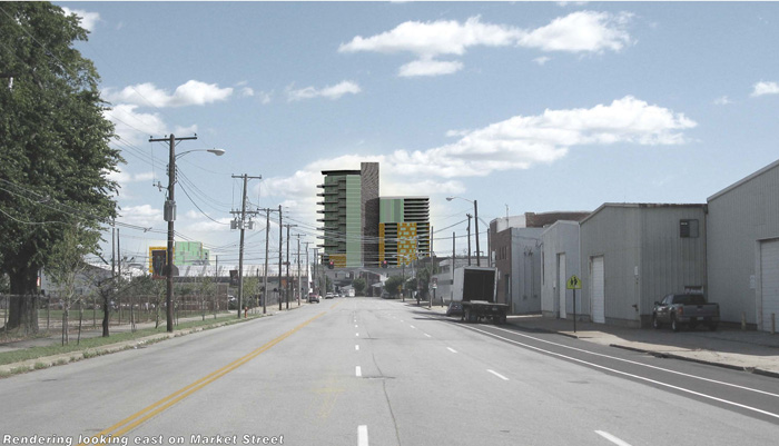
Most proposals included at least one tall structure to punctuate the horizontal landscape and create a visual reference for the surrounding area. This seems entirely appropriate as the site must serve as the town center for Irish Hill and one way to draw attention to such a designation is through scale.
As you can see in the rendering immediately below, the site will be visible in surrounding areas (in this case, East Market Street) and interjecting a point of scale is, in my opinion, a good way to designate that something is going on. It should be noted that this site shouldn’t be a new or second downtown, and the tall building should not predominate the built form.
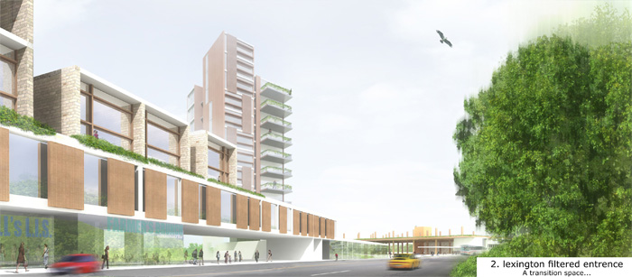
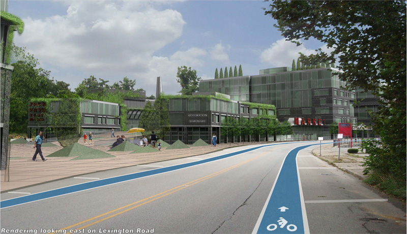
Common among most projects as well was an adherence to mid-rise scale ranging from three to five stories in various proposals. This mid-rise scale creates a vibrant walkable density without being overbearing on the existing historic neighborhood. It can also be seen as a response to existing site conditions including the five-story brick bourbon warehouses on Lexington at Distillery Commons.
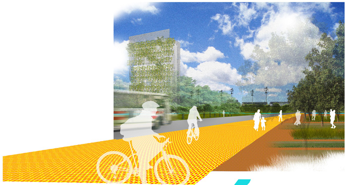
Below, you can see how various projects deal with height, generally including mid-rise urban edges punctuated by a signature tall structure.
Street & Site Manipulation
A few of the proposals chose to approach the site more radically—that is, considering starting from scratch. This could involve manipulating the course or behavior of Lexington Road itself as seen in two proposals below. I’m not sure what’s the best solution for Lexington Road—altering it or leaving it alone—without looking at the issue more in depth, but I think it’s refreshing to consider changing the existing street in a responsible way.
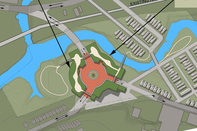
Above, you can see a proposal pulling Lexington Road into the center of the site and incorporating a roundabout to emphasize the center and literally force the user to interact with it. Below, Lexington maintains its existing path, but a spoke is extended into the site in a natural way that changes the corridor flow into more of a node.
Neighborhood Connectivity
One of the most challenging and important aspects to consider when approaching redevelopment of this site is how it connects—or in its present form, doesn’t connect—to the surrounding city. The site might be serving as the town center for Irish Hill, but it’s situated not only at the confluence of two forks of Beargrass Creek, but also of several neighborhoods.
Butchertown and Nulu are directly across the railroad tracks to the north and west and Clifton is to the northeast. It’s going to be important to engage these neighborhoods to create a real walkable center.
Right now, obstacles to connectivity include the meandering shape of Beargrass Creek, railroad tracks, an Interstate highway not far away, a large walled cemetery, and a tall cliff that gives Irish Hill its name. The presence of these challenges makes connectivity even more important.
While only a few proposals didn’t bridge the railroad tracks, most chose to do so either with roads as seen in two examples above or with pedestrian paths as seen in an example below. The obvious route appearing in many plans is a path or road connecting Mellwood Ave. near the creek to Lexington Road. A few pushed connectivity even further and provided paths east across the creek towards Spring Street.
I believe there must be some vehicular access between Lexington Road and Mellwood Avenue. The two major streets are pinched together at this point and are otherwise quite disconnected. This also allows a larger portion of the site to accept compact development as I described above. Overall, though, pedestrian connectivity should be pushed to the max to allow ease of getting around an area that will undoubtedly be growing in walkability.
Sustainable Components
Another vital component of this site is how it deals with rainwater runoff and sustainability issues. We talk about sustainable architecture enough here that I’m not going to go into those details such as green roofs now, but one factor that cannot be overlooked on this site is how development treats the Beargrass Creek watershed.
There are many approaches to tackle this issue. One obvious choice is to leave most of the site undeveloped. Further, if a large portion of the site is covered in trees, this will slow runoff even more. Green roofs on buildings and pervious paving could also help.
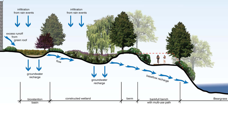
Because the creek is such a central focus of this site, though, bioswales are going to come into play as well. A bioswale is a small basin with native plantings that catches and slows rainwater runoff. It allows for some water to be recharged into the ground instead of simply rushing and inundating the creek. The diagram above shows a nice example from the Confluence project.
Other creative approaches were also presented. One project, Slow Urbanism, proposed a theoretical time-lapse site remediation and redevelopment that occurs over many years. Trees are planted, selectively harvested, a network of paths is established and the site is later built up.
Below, the Aeratorpark proposal also includes an extensive landscape component that actually filters pollutants from the environment. Â Contaminated earth from prior industrial uses is grouped around “phytoremediation swales.”
Architecture
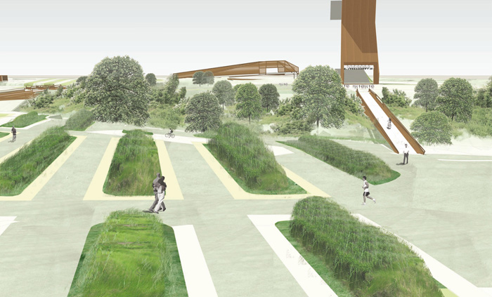
Lastly, I want to quickly touch on the architecture of these proposals. It’s safe to say that, when left to their imaginations, the designers of these projects have come up with some beautifully modern yet contextual architecture. Below is the marketplace pavilion from the winning entry, A Scenic Walkway, floating above the pond biotope landscape described above. The simple monumentality of this and other buildings in each proposal is really something to behold.
Whatever form the site takes in the future, it would be wise to learn from the Mediative Urbanisms proposals. I pointed out some of the lessons I drew from the presentations and I believe the currently abandoned site can one day be one of the most vibrant in Louisville.
Make sure you stop by the Urban Design Studio Friday at the Trolley Hop and check out all the proposals for yourself. What are your thoughts?


