
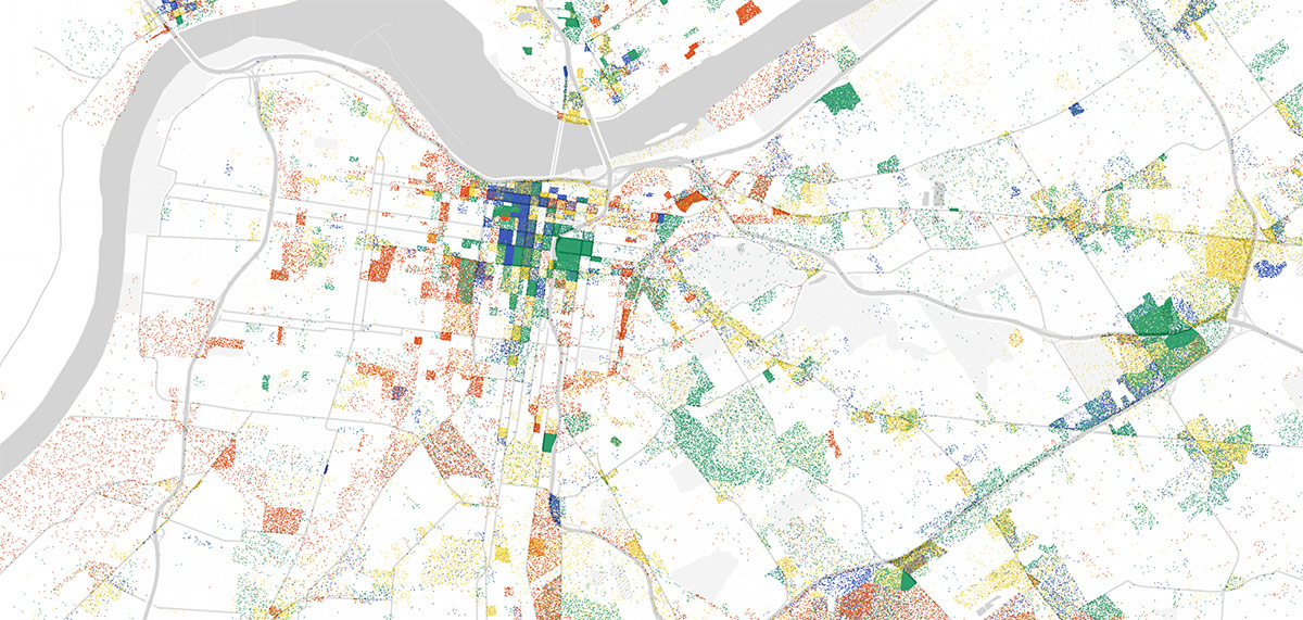
Where do you work in Louisville? While it’s common to think the vast majority of folks work in Downtown, there are employment hubs located all around our city. Downtown is certainly the densest concentration of jobs, but as sprawl continues its march across the city’s once rural landscape, many are commuting suburb to suburb—or even reverse commuting from a home in the city to a job on the outskirts.
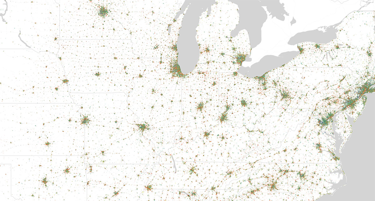
A mapping tool created by Harvard PhD sociology student and mapmaker, Robert Manduca, called “Where Are The Jobs?” uses 2010 LEHD Census data to reveal the spread of jobs across the entire country. So we decided to zoom in on Louisville to see what we could learn.

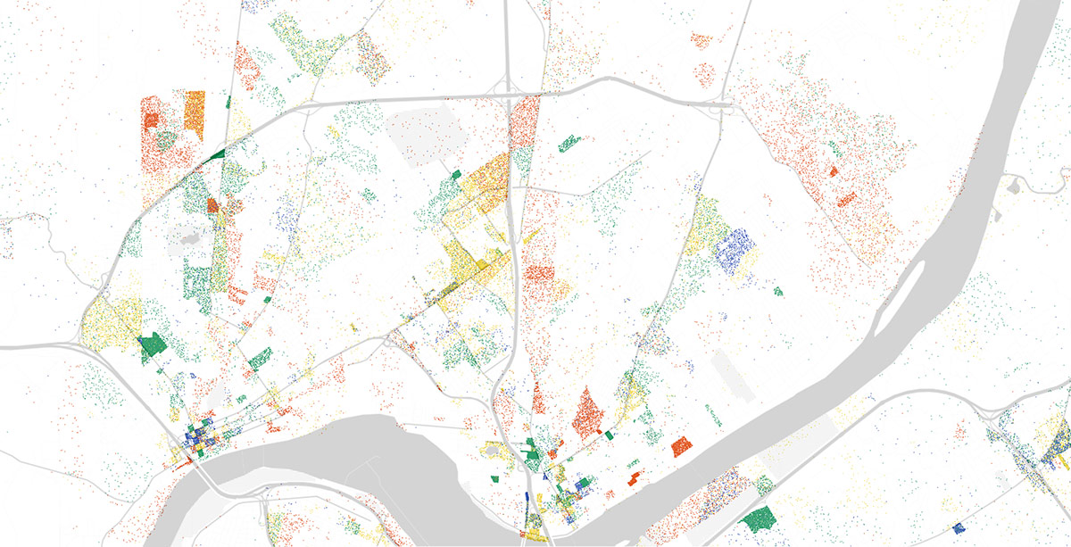
For reference, red dots indicate manufacturing and logistics jobs, blue are professional services, green show healthcare, education, and government, while yellow denote retail, hospitality, and other services. Each dot represents a single job, so, as you can imagine, there are a lot of places that begin to take on a solid color where major employment hubs are located.
What’s immediately noticeable in Louisville is that there are jobs everywhere. But a few key observations come to mind from this map. First, look at the concentrated green splotches on the map up above. Those healthcare hotspots correspond with where the city’s major hospitals are located. You can see many health workers Downtown—and even more just east of Downtown in the Medical District. But off to the northeast, another patch denotes the VA hospital at Zorn Avenue.
While these maps use 2010 data, were they to be updated with today’s data, you would see another major green area in the far eastern suburbs where a number of hospitals have been built not far from Norton Commons.
Another fascinating observation are the trails of yellow—service and retail jobs—that tend to follow arterial streets in the city. In these maps, the darkest yellow is clearly the confluence of Interstate 64 and Shelbyville Road where Mall St. Matthews and Oxmoor Center are a retailing mecca.
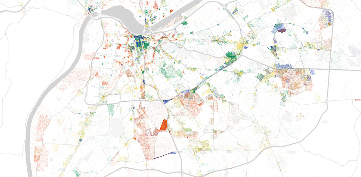
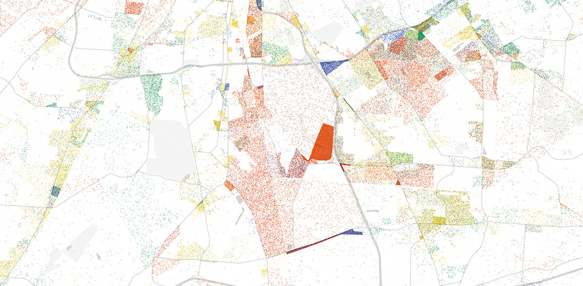
Elsewhere in the city, you can see Dixie Highway is almost entirely a yellow line, as is much of Bardstown Road. In the far eastern suburbs (below), that linear pattern of retail breaks down into larger dots marking major strip malls here and there along the side of the road.
While we’re out in the east end, take a look at the concentrated patches of blue, or professional jobs. These mark the city’s major office parks—the signature placeless mono-use culture of suburbia. You can see that the blue is dense, but not solid like it is in Downtown, noting the vast amounts of wasted land and parking lots between office buildings.
On the lower end of the above map is a hodge podge of colors, indicating a real mix of job types. That’s the Bluegrass Industrial Park out near Jeffersontown. It’s dot concentration also gives away its low density pattern, but the its sheer size shows that it is larger in land area than Downtown and some of its surrounding neighborhoods combined.

The red sections on the maps indicate logistics jobs, and it’s easy to see that solid red patch at the airport is the hub of Louisville’s logistics sector—the UPS WorldPort. Other logistics hotspots can be seen surrounding the airport and along the Ohio River in southwest Louisville where the city’s RiverPort is located.
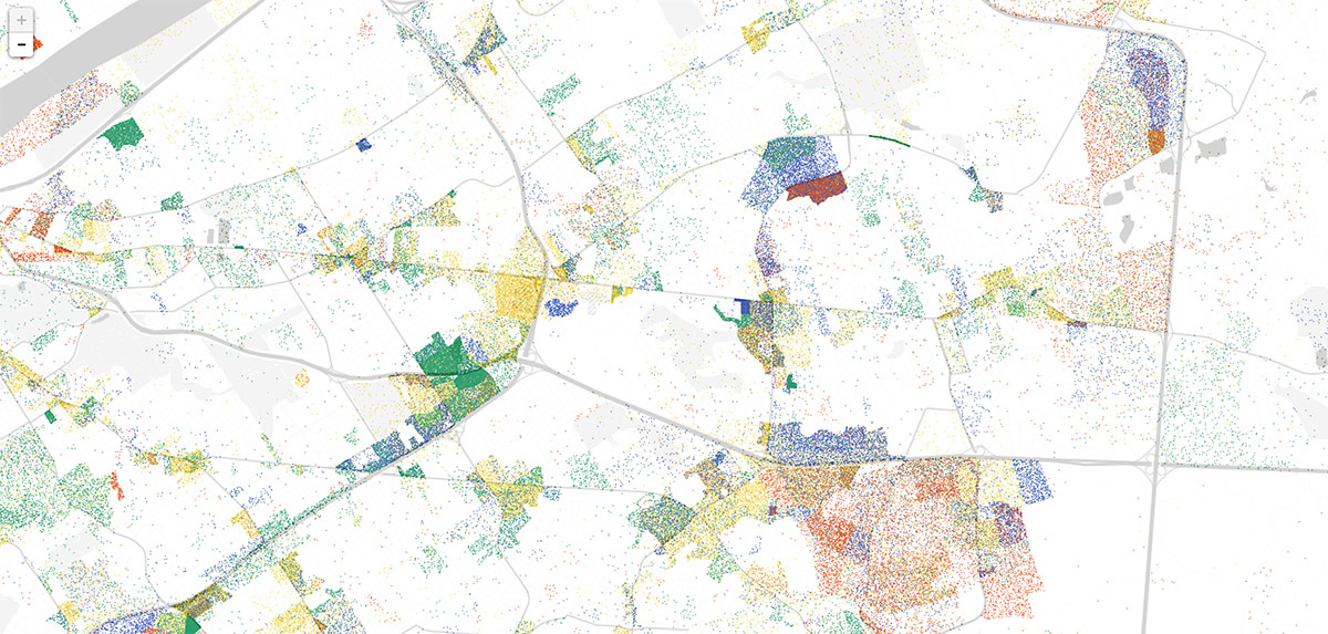
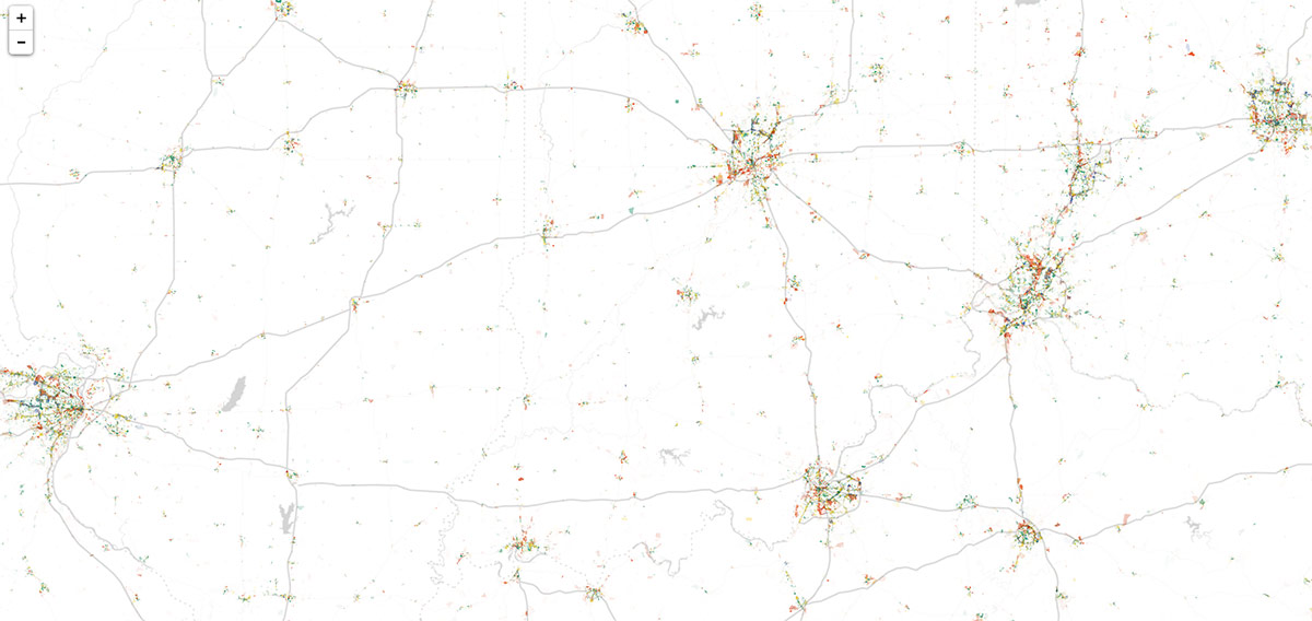
Finally, up in Southern Indiana, you can see similar trends at play. Downtown New Albany and Jeffersonville show dense concentrations of mixed-use activity while farther out, the dots disperse and concentrate in a less organized pattern. Retail is clearly centered around Clarksville sprawl.
Another emerging trend is the sprawling patch of dots in eastern Southern Indiana at River Ridge Commercial Center. In 2010, that area was just getting started, but since then, it’s grown significantly. And it will only grow more with the opening of the East End Bridge. It’s Southern Indiana’s answer to the Bluegrass Industrial Park.
One intriguing takeaway from these maps is a notion of where we might focus our residential building. Can we make the jobs hot spots in the suburbs into more walkable suburban town centers by infilling and making a sort of village feel? If Louisville ever decides to pursue a cluster of mini-downtowns surrounding the city core, this map is a clear guide on where to begin.
What observations do you see in these maps? Were you surprised by the geographic distribution of jobs in Louisville? Share your thoughts in the comments below.
“This visualization plots one dot for every job in the United States, according to the Census Bureau’s Longitudinal Employer-Household Dynamics data,” Manduca wrote about his map. “The LEHD data is based on state unemployment insurance records, and tabulates the count of jobs by census block. Here, jobs are colored by type, allowing us to see how different industries and sectors exhibit different spatial patterns—some clustering in downtowns, others spreading across city and suburbs alike.”
If you’ve got some extra time to kill, browse through the entire United States on the interactive map here.


I love maps. I’m relieved to see some density still exist downtown. Recent news has indicated that there is a trend for businesses to move back into the city center again. However, the blob of the east end disturbs me. I just don’t understand what sitting in traffic has for people. Suburban sprawl has never been a good thing and it will continue to bite us in the ass as it feeds on itself in the future. Hopefully, urban housing trends will soon surpass suburban as well. We have so much pre- built infrastructure downtown and inside the watterson that it’s a waste when land way out is turned into more suburbs.
Well to be fair, the high-end professional services places setting up shop in the East End along Hurstbourne and others are probably a reaction to people not wanting to sit in traffic for quite so long, and the sad acknowledgement that most of the people who hold those jobs don’t live or don’t want to live in the city center. It’s so sad to imagine what downtown could be like if companies chose to build and stay downtown when articles come out about them building in the suburbs.
Not all of these office parks are created equally though. The newest ones are set up sort of “peak car” style. But I personally see a lot of people walking and biking into the J-Town office park where there could be much more infrastructure to make the office park more livable. Plantside has a bike lane, but Watterson trail needs one too, as now parts don’t even have sidewalks, and I’d love to see the walking path that does exist connecting the neighborhood along Merioneth extended along the unused railroad tracks that would give people a safer way to get to most places within the park. There’s a planned bike lane on Watterson Trail west of Taylorsville that won’t connect anything at all really, but if that could be extended to downtown J-Town and the office park it would allow many people a comfortable way of commuting. Other office parks are probably hopeless in terms of giving people transportation options, but here I think there are some good options the city could easily implement.
While I understand the researcher’s use of red dots for both manufacturing AND logistics, as both generally represent “blue collar” labor opportunities, it would be even more interesting to see a distinction, specifically to show the number of manufacturing jobs. In the final analysis, only manufacturing provides “basic economy,” and ALL the rest combined — retail, service, professional, education, healthcare, AND logistics — are all non-basic economic activities that move around the money created by the basic economy. That is, without some sort of basic economy, we’re all unemployed for lack of $ to move…
Comments are closed.