This map shows just how much Downtown has changed in 60 years

Earlier this week, we took a look at an old editorial from 1955 calling for the bombing of Downtown Louisville to make way for modern development that would accommodate the automobile. It turns out, Louisville did, in a way, bomb itself away in the years after World War II, only in slow motion with a wrecking ball. Today, Downtown’s historic fabric has been decimated, still pocked with parking lots, poorly rebuilt buildings, and, sometimes, quality architecture that we’re lucky to have today.

The University of Oklahoma’s Institute for Quality Communities has documented Louisville’s night-and-day transformation in a research project published in December 2014 where aerial images from the 1950s are overlaid with modern views. Luckily, Louisville was included in the southeast region, and the institute has allowed us to share it here with you.

“The most rapid change occurred during the mid-century urban renewal period that cleared large tracts of urban land for new highways, parking, and public facilities or housing projects,” the institute wrote on its website. “Fine-grained networks of streets and buildings on small lots were replaced with superblocks and megastructures. While the period did make way for impressive new projects in many cities, many of the scars are still unhealed.”

louisville-torn-down-1952-2014-04

louisville-torn-down-1952-2014-03

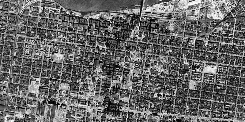
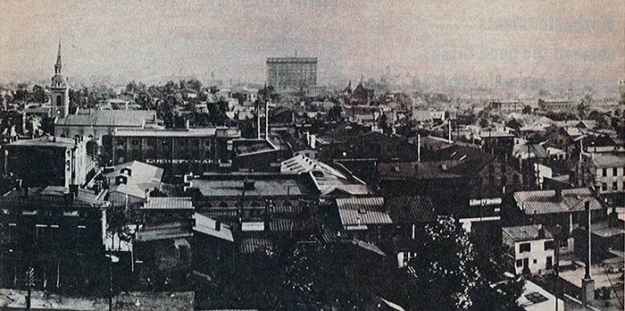
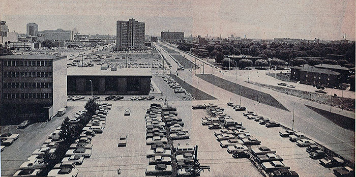
(Above: An aerial view of Louisville in 1952 and another view in 2014 shows just how much Downtown and its surrounding neighborhoods have changed. Courtesy TKTK)

Sliding back and forth between the two views reveals 62 years of urban evolution in Downtown and its surrounding neighborhoods. A lot has changed in that time. We’ve built several major Interstate highways through the middle of the city and connected them with an enormous junction, we’ve undergone multiple less-than-sensitive urban renewal campaigns, and politicians through the years have pushed through mega-projects that reshape large swaths of the city in one fell swoop.

The density in the 1952 view is somewhat astounding. Louisville was once a lively city of fine architecture and bustling streets. But as the city eroded building by building, or block by block, that vibrancy left with it. Today, it’s hard to call Louisville a historic city when you look at just how much has been lost.

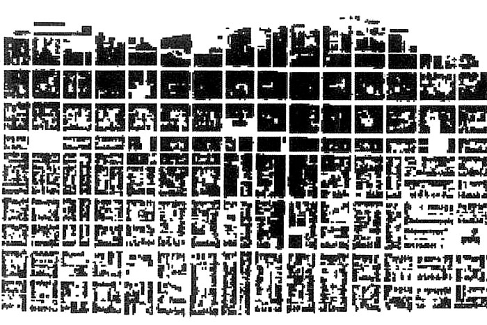
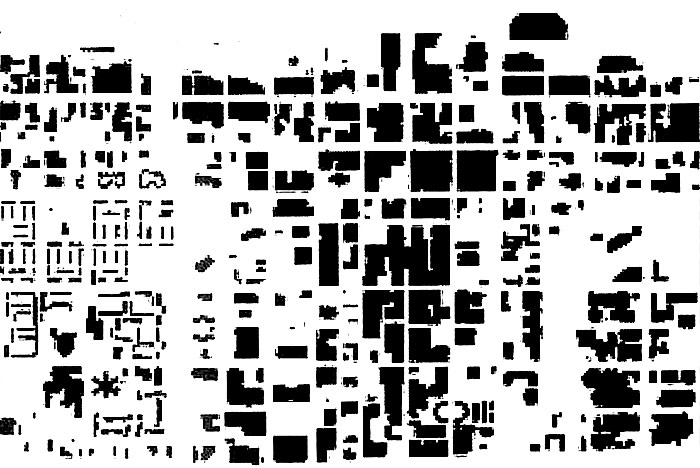
Sure, we’ve got some great preservation districts and historic neighborhoods, most notably Old Louisville, but we’ve carelessly tossed aside Louisville’s heritage of urban architecture and there’s no getting it back. To see just how much was lost, we colored in areas in the 1952 image that were torn down since World War II. Take a look below.

louisville-torn-down-1952-2014-01

louisville-torn-down-1952-2014-02

(Above: The 1952 map showing in red just how much of pre–World War II Louisville has been lost. On the right, only the areas of pre–WWII Louisville demolished. Montage by Broken Sidewalk.)

A brief note on methodology: We’ve colored in every pre-war block that’s no longer with us. Sometimes these blocks were rebuilt and today contain buildings. Also as likely, they’re now surface level parking lots. We’ve also chosen to include the early housing projects of Beecher Terrace and Clarksdale in this representation. While they were built before the war, they represent an early case of urban renewal, clear-cutting vast swaths of the city’s original fabric. We also included the train sheds and tracks at Union Station on Broadway but not an industrial rail yards on the waterfront. The passenger rail infrastructure could be considered just as significant a loss as much of the city’s built fabric.

While making this updated map, we noticed a few interesting points. First is that much of what was lost was dense yet leafy neighborhoods immediately surrounding Downtown. These areas, around today’s Medical Center, Phoenix Hill, and Nulu on the east and in Russell and Portland on the west. These areas were considered slums at the time, whether they deserved the title or not. Some of them were dirty and overcrowded, but more often they contained people the city wanted to push away, such as a thriving black community in western Downtown.

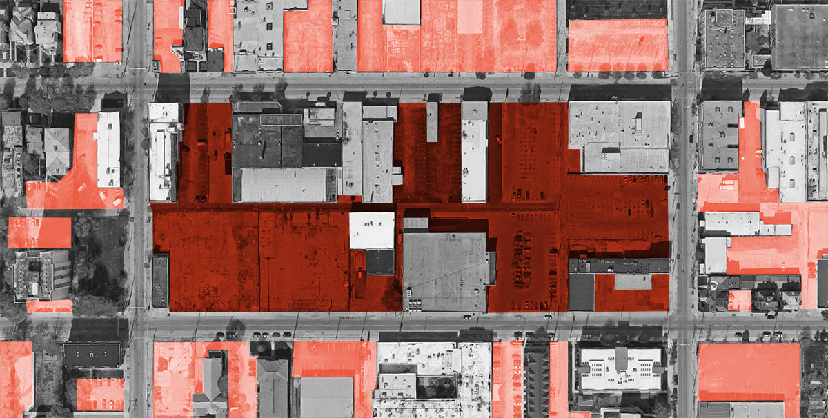
Also of note is how many parking lots are already appearing on the scene by 1952. You can begin to see the erosion of the city, especially around Broadway with a notably large parking lot at Ninth and Broadway. In an effort to attract suburban shoppers, business owners often would demolish an adjacent structure and advertise free parking. The process was just beginning to speed up around this point.

Another observation is just how many entire blocks were entirely clearcut over the years. Most often, this didn’t happen all at once, with a few notable exceptions like construction of megaprojects like the convention center or the Hyatt hotel. Usually, buildings were lost one by one, like grains of sand falling through an hourglass. It’s harder to notice an entire city slipping away when it happens so slowly.

Finally, it’s also interesting to note the industrial area along the waterfront near today’s Slugger field and north of Butchertown. These areas have been remade today as Waterfront Park and Spaghetti junction, but 60 years ago, they were the city’s hectic industrial quarter.

What’s not as visible on these maps is another kind of change over the past century: transportation. Looking at the modern and historic views, you can discern some streets that urban renewal and highway builders rerouted to speed up automobile traffic through Downtown, but it’s harder to tell the fine grained city that was lost to these realignments. Further, the loss of Louisville’s streetcar network, once among the nation’s best, cannot be left out of a discussion of how the city has changed since the 20th century.

What observations do you see in these maps? Share your thoughts in the comments below.

Head over to the University of Oklahoma’s Institute for Quality Communities to view more before and after views from other cities in the Southeast including Nashville, Memphis, New Orleans, Atlanta, Charlotte, and more.


Naomi Doerner on how street safety advocates can support racial justice

A bike ride through New Orleans. (Courtesy Bike Easy)

streetsblog-logo-02When a police officer in Falcon Heights, Minnesota, shot and killed Philando Castile earlier this summer, the encounter began with a traffic stop. The stop fit a pattern: Castile had been pulled over many times before—46 times in 13 years. But few of those citations were for dangerous driving. More prevalent were stops for minor issues like vehicle defects or misplaced license plates—the type of justifications that police are more likely to use when stopping black and Latino drivers throughout the country.

Street safety advocates often call on police to reform traffic enforcement practices in order to reduce dangerous driving that jeopardizes people walking and biking. Given the pervasiveness of racially discriminatory police work and the prevalence of police brutality in many communities, how should biking and walking advocates shape their strategies and messages?

Naomi Doerner helps biking and walking organizations develop social equity and racial justice plans. (Courtesy Bike Easy)

Naomi Doerner, the former executive director of New Orleans’ advocacy organization Bike Easy, is a consultant who specializes in helping biking and walking advocates develop racial justice and social equity plans. She says advocates should be grappling with structural racism and considering how their own choices can entrench or dismantle it.

Here is a lightly edited transcript of our interview.

What’s a mistake some biking or walking organizations are making with regards to diversity?

I think that one of the things I see is hiring of people of color and then making them sort of the voice for diversity and equity, which are not the same thing.

It is great to hire the folks, to have the folks who do potentially have better understanding. Even if you had a staff that was diverse, if there’s not a co-created understanding of equity within your organization and how you’re contributing to it, it won’t succeed.

Participation and engagement with communities is one of the things people can do. If you want to engage communities that are different than your own, then it is important to go to those communities without an agenda and listen. Where and when authentic relationships form, if there are opportunities, it may not be about a bike lane. If you have access to funders, you have resources that you can bring to the table to really help contribute.

It’s a long process but I think that’s really what is needed: Helping communities to achieve the goals for themselves. And find the commonality.

What can individual advocates do to be more sensitive? 

The individual racism isn’t the actual issue. There are very few people that are going to be overtly racist. It’s the bias. It’s where and how it’s embedded into our institutions.

Each of us has a role in addressing institutional and systemic racism. It sounds really scary. It involves making a personal choice to get unstuck and find groups (Note: Doerner recommends Race Forward or SURJ.) and people who can support you in your personal growth. Whatever role you have, you can start to identify your privilege and seeing your privilege as a tool you can use to dismantle racism.

As a writer, you can use your role to address issues of systemic racism. As a planner, I can address systemic racism. In planning, any project is inherently going to create unforeseen byproducts and outcomes that can potentially be very detrimental to a community that you might not see.

Can you give an example of that?

I’m just going to use Vision Zero. A lot of people are talking about it. Vision Zero is a policy that was really adopted from a Swedish model and it was enacted at the country level, and its [goal is to] reduce fatalities to zero by [a certain] time frame. In the context of Sweden it has been seen as a success. There’s been a move to understand that in the United States. Now we’ve had a national campaign come here and it’s compelling. Vision Zero and the goal itself to reduce fatalities in a community—that’s what livable cities planners want.

It’s been very top-down for the most part, getting city and transportation agencies to adopt that at the ordinance level. It’s been a mostly top-down process where advocates have done this education of what it is. Legislators are happy to endorse it.

When you look at what is happening in communities of color in cities where we have this broken windows policing and you overlay this Vision Zero enforcement, there are concerns that it could lead to this kind of profiling or traffic stops.

What a lot of social justice and racial equity [advocates] are calling for is not just reform—what about community policing? If we’re going to be giving more investment to police enforcement, it has to be communities telling police how and where and what.

This particular Vision Zero analysis had not been done by the advocacy community. I think that a lot of that really does have to do with the fact that a lot of the organized bike and walk community are not comprised of people of color. There are a very high number of people of color who bike and walk. But generally, they’re not really helping shape policy or the campaigns.

It doesn’t mean that you throw out everything about Vision Zero. It just means we have to use analysis tools to figure out who could very well be negatively impacted and develop alternatives.

I read a blog post you wrote about growing up in an immigrant family. How does your background inform your work?

My mother is from Honduras and Central America. She had me at 21 and was a single mother until she got married. Being very young, I distinctly remember walking with my mom in the cold to the bus stop in Chicago and that’s how we got around. It was my mother’s way of really going up the ladder. [After] my mom married my dad—he was someone who was college educated—I didn’t take the bus. The communities I lived in were different.

My mother and I in those early years, that has always informed the work that I do. It’s really about prioritizing the needs that people have to live their lives and support their families.

[This article has been cross-posted from our partner, Streetsblog.]

Louisville’s bike share system delayed another year till 2017

Louisville will have to wait another year for its planned bike share system. While the city’s bike and pedestrian department, Bike Louisville, continues to make progress building bike lanes and neighborways, Coordinator Rolf Eisinger told Broken Sidewalk that the earliest the program could launch is next spring.

The city announced the bike share system in December 2014, hoping to launch in the summer of 2015. Plans call for 300 bikes to be distributed throughout 30 stations located in Downtown, Nulu, Butchertown, the Medical District, Smoketown, SoBro, Old Louisville, and around the University of Louisville’s Belknap Campus. (Humana has long-operated its own small private bike share system for its employees under the B-Cycle brand with a few stations around Downtown.)

Charts show the feasibility of Louisville's bike share system. (Courtesy Bike Louisville)
Charts show the feasibility of Louisville’s bike share system. (Courtesy Bike Louisville)

Santa Monica–based CycleHop was selected to run Louisville’s program. When the program was first announced, the city said prices would range from $3 for a single trip over a 30 minute period to $7 for unlimited trips totalling no more than an hour over a 24-hour period.

In June 2015, Bike Louisville announced that the program was delayed a year, until summer of 2016. At the time, Eisinger said the delay was largely due to coordinating the locations of the bike share stations with utility companies, public works, and the state.

But as summer winds down, there are still no bike share stations parked on Louisville streets. Eisinger said the delays are not due to finding a sponsor for the program since it’s being paid for with user fees and $1.63 million in federal, city, and university funds: about $1.3 million from a federal grant, $250,000 from the city, and $70,000 from UofL. To date, no sponsor has signed on, however. As such, there’s no branded name for the program.

“I wish I had better information than we’re hoping to launch in the spring,” Eisinger said. “We’re working with our contractor, CycleHop, right now, finalizing some agreements.” He also said the program was delayed because of the process of using federal funds. He previously told WFPL in January that the federal grant must be approved by the Kentucky Transportation Cabinet.

“A lot of it was culture change,” Eisinger said. “This is something very different for our community. Getting everyone comfortable with the idea takes some time.”

Demo bikes in Santa Monica. (Courtesy CycleHop)

While bike share might be different for Louisville, it’s nothing new around the United States. Just this summer, CycleHop launched programs in Atlanta; Cleveland; Vancouver, Canada; and West Hollywood. Louisville’s program is the only one still under development, according to the company’s website. Bike share systems also recently launched with different companies in Birmingham, Alabama; Buffalo, New York; Fort Wayne, Indiana; Los Angeles; and a long-delayed system in Portland, Oregon. In short, most cities across the country already have these systems in place. Louisville is officially playing catch up.

Still, some bike leaders in the city are skeptical of even a 2017 launch. “I’m not surprised it’s delayed,” Chris Glasser, executive director of Bicycling for Louisville, told Broken Sidewalk. “Spring 2017 isn’t realistic either. Bike share needs safe east–west connections across Downtown to be viable, and there’s no political will in the Mayor’s office or Metro Council to see that those kinds of facilities go in.” He pointed to Jefferson, Market, and Main streets as being grossly overbuilt for automobile traffic, noting that they are ripe for lane reductions. A major redesign of East Market Street including a potential protected bike lane is planned but long behind schedule.

Glasser would also like to see the target area for bike share stations expanded. “Bike share will be a failure until it includes the inner Highlands,” he said. “Expand the service area and create a safe connection into Downtown, and then you’ll have the possibility of a viable bike share system.”

In many cases of successful bike share systems, a robust network of bike infrastructure has proven to be key. Glasser expects the winners and losers of the recent rapid expansion of bike share across the country to become clear in coming years. He pointed to a system in Seattle that’s already facing ridership and financial struggles.

Bike share systems are more than short term bike rentals placed throughout the city. They’re considered an extension of a city’s transit system. They help bridge that last mile between taking transit and a person’s destination. They’re also potentially effective at reducing vehicle miles traveled as they simplify diverting short trips from the automobile to bike.

The city's Suggest-a-Station map. (Courtesy Bike Louisville)
The city’s Suggest-a-Station map. (Courtesy Bike Louisville)

In the meantime, the city has also not yet finalized the locations of where the bike share stations will be located, and Eisinger said citizens can still weigh in using an online mapping tool. “We still have our ‘Suggest-a-Station‘ [website] online,” he said. “We welcome people to do that.” You can view that website here (be sure not to use the www. or it won’t work).

Ultimately, it’s better late than never for Louisville’s bike share ambitions. We’ll be just as excited if it launches next year as if it launched this summer. But it would be nice to get ahead of the game on something like this rather than let other cities like Chattanooga, Birmingham, Greenville, S.C., Madison, Wis., and Milwaukee take the lead. The future of Louisville depends on the city competing on a national stage.

Land Development Committee hears Russell mixed-use, East End sprawl Thursday

Rendering of the building. (MOLO Village / Via Metro Louisville)

The Land Development & Transportation Committee of the Louisville Metro Planning Commission will hold its next meeting at 1:00p.m. on Thursday, August 11 at the Old Jail Courtroom, 514 West Liberty Street. Three items are on the agenda: two sprawling developments far out in eastern Jefferson County and a mixed-use retail building planned on Jefferson Street in Russell.


02-sutherland-pointe-sprawl-subdivion-louisville

01-sutherland-pointe-sprawl-subdivion-louisville

First up, Sutherland Point (16SUBDIV1011), a subdivision plan to create 237 buildable parcels (and four unbuildable) on 101.4 acres at 15905 Aiken Road. The committee will also review a Floyds Fork Development Review Overlay (DRO) Plan. The lots would range from 5,500 square feet (0.13 acres) to 29,689 square feet (0.68 acres). Not included in this count is a parcel containing the historic Yeager House on its own 52,885 square foot (1.21 acre) lot.

The property is owned by Sonyjean, Inc. and Indianfield Farm, Inc. and the developer is Redwood Acquisitions, LLC. The applicant is represented by Bardenwerper, Talbott & Roberts and the site plan was drawn by Mindel, Scott & Associates.

The site plan calls for a 100-foot undeveloped buffer along Floyds Fork creek, which forms the northern boundary of the site. Much of that land is comprised of steep slopes that are not buildable and the developer is seeking to transfer the building rights (of 21 lots) to the rest of the site. Another 60-foot buffer is planned along Aiken Road. In total, the four unbuildable lots comprise about 33 percent of the total site area, making the net land area 88.61 acres. A staff report makes clear, though, that this proposal is not a conservation subdivision.

The property is located in the Floyds Fork Development Review Overlay District. According to a staff report from Metro Louisville Planning & Design Services, the development meets the overlay standards “by providing adequate buffers from the stream, minimizing disturbance of steep slopes and woodland areas, and providing a 60-foot scenic corridor buffer along Aiken Road.”

According to plans, that means the density of the subdivision is 2.34 dwellings per acre, which is lower than Louisville’s average countywide density of 3.01 dwellings per acre. This is a pretty typical farm to auto-dominant sprawl conversion, and the staff report recognizes it, calling for a binding element that developers contribute $240,000 for a new traffic signal and turning lane at Aiken Road and Bush Farm Road. If Louisville is going to meet its goals of becoming a more multi-modal city and decrease reliance on the automobile, we’d better figure out how to discourage urban design like this—or the continued development of farmland on the city’s edge.


03-blankenbaker-center-2-louisville-office-park

02-blankenbaker-center-2-louisville-office-park

Next, the committee will review a development plan for Blankenbaker Center II (16DEVPLAN1124) at 11820 Ransum Drive in Middletown. The property is owned by Kentucky Property Investments and is proposed for development by Pinnacle Properties of Louisville. Pinnacle is represented by Bardenwerper Talbott & Roberts.

Office building clones. (Google)

As you’ll recall, Pinnacle is also developing an office park with nearly identical building design over in Lyndon that relies on nearly identical building design as Blankenbaker Center I. It seems these postmodern boxes designed by Studio Kremer Architects are taking over the city.

05-blankenbaker-center-2-louisville-office-park
Clone office buildings next to the proposed office park. (Google)

This second phase of Blankenbaker Center surrounds a large parking lot with neat rows of buildings, efficiently fitting as much parking and built space as the site can hold. That’s a stark contrast to its neighboring office park that plopped down office building clones along zigzagging streets in any which manner.

At any rate, Blankenbaker Center II proposes six new two-story buildings each 6,200 square feet. Just like at its Lyndon counterpart, this proposal includes more parking than the city’s minimum requirement (no transit bonus out here in the exurbs). The required parking ranges from 111 spaces to 195 spaces, with developers opting to build 133 spaces. And just like Lyndon, that means there’s more parking lot area than actual building area (39,000 building vs 43,225 square feet of parking lot). Two bike parking spaces are required and will be provided. A large rainwater detention basin is included in the site plan to store all the runoff from that parking lot.

A typical building elevation. (Pinnacle Development / Via Metro Louisville)
A typical building elevation, designed by Studio Kremer Architects. (Pinnacle Development / Via Metro Louisville)

In terms of tree coverage, the site currently contains 58,894 square feet of canopy (48 percent of the site) and the plan will preserve 7,920 square feet of that. Developers will plant back to 25,767 square feet, the minimum required by code, or 21 percent of the site.

As is the case with Pinnacle’s project in Lyndon, Blankenbaker Center II plays it by the book. Except for a building height variance (16VARIANCE1054) that will be heard by the Board of Zoning Adjustments (BOZA) on August 15, the staff report concludes, “This development conforms to the Land Development Code and the Comprehensive Plan as all requirements have been met.” It’s hard to fault the developer when they’re playing by the rules we’ve set out for them. It’s time we reconsidered how our codes and comprehensive plans are actually shaping the built environment.


Site plan for the Village at West Jefferson. (MOLO Village / Via Metro Louisville)

Finally, the committee will look at a rezoning request for the Village at West Jefferson (16ZONE1000) at 1225–1231 West Jefferson Street on the corner of 12th Street in Russell. The property is part of St. Peter’s Evangelical Church, as we’ve previously reported. The project would be developed by MOLO Village Community Development Corporation. This is just a baby step for the project, however, as the committee will be setting a public hearing before it goes to the full Planning Commission.

Plans call for building an L-shaped, two-story mixed use building with retail and office space. The structure would cover nearly 32,000 square feet. The building was designed by Kovert Hawkins Architects. The site is currently located in a Traditional Neighborhood Form District.

Rendering of the building. (MOLO Village / Via Metro Louisville)

As in the previous two cases, Louisville’s parking minimums come into play, despite being in quite an urban site just a few blocks from Downtown. According to plans filed with the city, a minimum of 67 spaces must be provided for the church (one space per three seats) and 75 spaces for the commercial building (one space per 350 square feet). That’s the same parking requirement for the office building located way out off Blankenbaker Parkway. Subtract ten percent for being near transit, and the site’s minimum stands at 128 spaces. The site plan calls for 71 on-site parking spaces and 13 on-street spaces, 44 below the minimum.

11-louisville-st-peters-church-molo-retail-russell
The structure would be built at 12th and Jefferson streets. (Via Google)

To move forward, the site must be rezoned from its current R-7 to CR, or Commercial–Residential, and it needs approval of its Detailed District Development Plan. According to a staff report, the committee will set a public hearing for the project. Later, it will go before the full Planning Commission, which will make a recommendation to Metro Council about rezoning the site.


The Land Development & Transportation Committee meets regularly on the second and fourth Thursday of each month. Meetings begin at 1:00p.m. in the Old Jail Courtroom, 514 West Liberty Street. Meetings are open to the public. The committee reviews requests for zoning changes, subdivisions, schedules public hearings, and makes recommendations to the Planning Commission, according to Metro Louisville.

Bike Louisville on where you might see the city’s next bike lane

Bike Louisville is busy building the city’s bike network into a connected grid of bike lanes and neighborways that will help Louisville cyclists better navigate the city—or perhaps encourage a few more to take to two wheels. Just take a look at this Gif of the Louisville’s bike infrastructure expanding year by year.

And this year is something of a challenge to keep up with last year’s pace. After receiving its first official budget allotment—$300,000—back in 2013, a number that was renewed in the 2014 budget, Bike Louisville jumped up to $400,000 last year. It had hoped to grow again this year to $500,000, but Metro Council slashed the bike budget to just $350,000 for the next fiscal year. Still, Rolf Eisinger, pedestrian and bike coordinator at Bike Louisville, has a lot planned.

While its name has “bike” right there front and center, Bike Louisville actually covers pedestrians and cyclists in the city. As such, Eisinger said he tries to promote “more of a complete streets model” when approaching a street redesign. “We’re looking at it more in a wholistic point of view,” he said. “When we touch a street, it’s more than just bike improvements. It’s safety for pedestrians and motorists, too.”

Some of the changes that benefit more than just cyclists are pedestrian bumpouts or neckdowns that make crossing a street easier. Eisinger also noted that his agency has been adding plastic  delineator posts throughout the city to make safety improvements more visible. “Those are the small, low-hanging tools,” he said.

02-bike-louisville-update
An example of signage that could make getting around Louisville on bike easier. (Courtesy Bike Louisville)

Keep an eye out for more bike infrastructure in the coming year. Eisinger said the city’s neighborways network of low-traffic, low-stress streets marked with sharrows will continue to grow. While some physical barriers associated with neighborways in other cities like traffic diverters aren’t on the table, Eisinger said he continues to push for adding new signage to help cyclists find their way. “Signage is on our short list as a priority,” he said. “And getting additional shared lane markings per the implementation plan, catching up with that.”

There will be additional new and revamped bike lanes as well. Eisinger said lanes on Seventh Street between Broadway and Chestnut Street will be redone to be more in line with what Sixth Street looks like. A bike lane on Goldsmith Lane from Bonair to Bardstown will also get an major redesign. “That bike lane is going to get overhauled,” Eisinger said. “We’re going to try to do a separated bike lane and add some delineator posts to show motorists where they should be driving.”

A bike lane on Sixth Street features green paint. (Courtesy Bike Louisville)

New bike lanes along 12th and 13th streets that got under construction in June are almost done. “We’re waiting to get some delineator posts in,” he said. Also coming up, Bike Louisville will be reworking a block of Fourth Street between River Road and Main Street. “We’re really trying to make those connections to the river better,” he said. “It really helps connect the network a little more. Not that long ago you couldn’t ride from one bike lane and turn onto another bike lane to get to your destination.”

There’s also a lot of maintenance planned on the bike network. “Immediately, we’re going to move a couple of the linear posts so they stop getting hit so frequently,” Eisinger said. That include moving posts at Third and Breckinridge streets to better accommodate TARC buses.

If you’re interested in staying up to date and adding your input to what gets built around Louisville, Eisinger recommended following along with the Louisville Metro Bicycle Master Plan (PDF). “The plan does a really good job of outlining the projects we’re hoping to implement,” he said. “I’m foreseeing there being an annual plan update. With that comes public involvement.” He said the next opportunity to update the plan will likely be this November or December, but said no details are ready.

Bike Louisville continues to follow a number of other longer term projects. One of those projects identified via public meetings is potentially installing bike infrastructure along Jefferson Street, he said. But he noted that with construction beginning on the Kentucky International Convention Center, any activity along Jefferson would be a couple years away. “We try to coordinate and work around other projects,” he said. “We’ll see where that lands.”

Eisinger said he will continue to push for an increased Bike Louisville budget in coming years. He said a lot of progress could be made educating members of Metro Council on the benefits of biking could go a long way. “I think highlighting the number of people who either can’t afford a car or choose not to get around by car in their districts so they hear both sides of the coin,” he said, noting that it often feels like they hear mostly from constituents who drive.

It’s about “changing the conversation so that it’s not bikes vs cars,” Eisinger said. “Roads are our public asset. How do we want them to function?”


Axis Apartments continue to climb on Lexington Road

The Axis Apartments on Lexington Road. (Branden Klayko / Broken Sidewalk)

Construction of the $45 million Axis Apartments on Lexington Road is moving steadily along since we last stopped by in April. Last week, we stopped by the Irish Hill site across from Headliner’s Music Hall to snap a few photos of the site.

“Considering all the rain we’ve had we’re doing pretty well with the schedule,” Brian Evans, an associate at developer Cityscape Residential, told Broken Sidewalk. “It’s been a difficult year to build.”

The Axis Apartments on Lexington Road. (Branden Klayko / Broken Sidewalk)

Still, the five-story, 300-unit project is moving right along. “We are putting the roof trusses on the first building now,” Evans said. He said the building to the north, off Lexington Road, will be next to top out—it’s already up to the fourth floor. Workers began framing the walls of the western building along Lexington just this morning. The elevator column has stood for some time like a concrete block obelisk on the site.

“We will be delivering units in [the first] building in the middle of January,” Evans said. He noted that the clubhouse and leasing office in that building is scheduled to open by November 1 and that pre-leasing will begin in mid-October. Units range from $800 to $1,700 per month. “We’re projected to be complete with the project in the middle of July,” he added.

Rendering of the Axis Apartments on Lexington Road. (Courtesy Cityscape Residential)

Watching the construction site, you’ll notice some red-colored framing going up around the perimeter. “That’s fire treated lumber,” Evans explained. He said it’s typical to see on a five-story, type 3 construction building. “Once you get up to five stories, you’ve got some special fire treating you’ve got to do.”

Walking along Lexington, you can begin to get a sense of the mass of the structure defining the street edge as an urban place. Distillery Commons has long provided that edge to the south, but the north side has never had the same street wall.

Besides adding to the urban feeling of the area, Evans hopes the buildings will also slow down Lexington Road’s notorious speeding motorists. “I’m hopeful that when the third building comes up it will slow traffic a lot on Lexington Road,” he said. “When you’re out here from 3:00 to 5:00, they come around the corner heading to Grinstead at a pretty good pace.”

And once the Axis’s 300 units begin filling with tenants next summer, Evans believes we could see additional development take shape in the area. “We’re hopeful it will spur some further redevelopment in the corridor,” he said.

Three houses on Lyndon Lane to make way for office park and large parking lot

Rendering of the office park as viewed through a buffer to the residential neighborhood. (Pinnacle Development / Via Metro Louisville)

While looking through the city’s wrecking permit requests for our #DemoWatch page recently, three adjacent houses in Lyndon built in 1951 popped up (WR995210, WR995204, WR995208). They’re being demolished for an office park right at the main crossroads of the suburban town.

The Lyndon Lane Office Condos project was unanimously approved by the Louisville Metro Planning Commission back on April 7 (six commissioners present, four absent), following the advice of a staff report from Metro Louisville Planning & Design Services. Developers at Pinnacle Properties of Louisville needed the site to be rezoned from its previous R-5 and C-1 classification to OR, or Office–Residential, along with approval of its detailed district development plan and the granting of a waiver from section 10.2.4 of the Land Development Code to eliminate a required buffer.

(Pinnacle Development / Via Metro Louisville)

The development plan, laid out by Mindel, Scott & Associates, follows Louisville’s land development rules for this area quite closely, which the staff report from Louisville Metro Planning & Design Services points out. The result is, unsurprisingly, a very suburban, auto-centric office park. The site is classified under the Neighborhood Form District, which means, according to the staff report:

The Neighborhood Form is characterized by predominantly residential uses that vary from low to high density and that blend compatibly [sic] into the existing landscape and neighborhood areas. High-density uses will be limited in scope to minor or major arterials and to areas that have limited impact on the low to moderate density residential areas.

(Pinnacle Development / Via Metro Louisville)

The project calls for seven two-story office buildings, each 35 feet tall, to be distributed across the 2.73-acre site. Each building ranges from just over 6,000 square feet to 6,400 square feet. According to developers, the structures will look like other buildings it has built in office parks around the suburbs, like the image shown but with a shingle roof.

Previously, in early 2015, two suburban-style apartment buildings standing three stories tall with large pitched roofs and positioned behind the houses on Lyndon Lane were proposed for the site, which drew complaints from neighbors for being out of scale.

(Pinnacle Development / Via Metro Louisville)

Plans call for the property to be developed in two phases. Most of the site will be covered in surface parking lots, which will require clearing all of the site’s existing trees.

Right now, 52,164 square feet of the site is covered by tree canopy (about 44 percent), of which none will be preserved, according to plans filed with the city. Developers will plant back the minimum coverage required by code, or 25,016 square feet of tree canopy, covering 21 percent of the site.

(Pinnacle Development / Via Metro Louisville)

To handle the rainwater runoff from all of that parking, a large stormwater detention basin is planned in the back of the site. Louisville codes require that new developments like this maintain pre-development levels of runoff. That basin will cover 6,865 square feet and is shown as two feet deep.

The three houses to be demolished. (Metro Louisville)

While most of the planned buildings line the parking lot, two of the structures shoulder up to Lyndon Lane, creating something of a sense of an urban edge along the street. That’s where the demolition of the three houses at 504–510 Lyndon Lane come in. The houses are typical small Cape Cod suburban houses from the ’50s ranging from 830 to over 1,200 square feet. Demolition can take place beginning September 3, 2016.


This kind of development is exactly the kind Louisville’s code recipe calls for. And the Planning Commission strangely praised it in its findings of fact as a development that will reduce Louisville’s exorbitant vehicle miles traveled rate: “[T]he proposed office condominium community is located at the heart of the Lyndon Town Center, thus reducing vehicle miles traveled for people already engaged in commerce and residing in this area; and reduced miles traveled leads to improved air quality.”

That’s an unexpected conclusion to draw, given that this project provides well over the parking minimum required for the site. It seems from the arrangement of buildings on the site plan and the consideration of the site individually from the larger Lyndon town center, that most people will be driving to work at this development.

According to project plans, code requires 114 to 221 parking spaces and no bike parking spaces (there’s a ten percent transit route reduction available on this site). Developers are providing 165 car parking spaces and four bike parking spaces. That’s 45 percent more than the minimum, meaning there’s one parking space for every 268 square feet of office building. Considering one parking space and the associated aisle space required to serve it covers 325 square feet, there’s more area dedicated to parking than the actual office use. (Even the parking minimum here calls for a high one space per 350 square feet.)

“The Lyndon Town Center has proven to be a great location for office condo buildings of this kind,” the Planning Commission’s finding of fact stated, “because it is a center of fairly intense residential and commercial activity; and therefore, redeveloping this overall site will lead to a continuing revitalization of the Lyndon Town Center.”


This office park is already approved and is headed for construction, but perhaps we can learn a few lessons that can help inform updates to our Land Development Code to promote more compact, more walkable development that will, in fact, help reduce vehicle miles traveled—which this one will not.

First off, Louisville would do well to actually begin planning rather than leave it to developers to build out individual parcels piecemeal. The Lyndon Town Center isn’t much of a town center today, and this development won’t change that, but if we planned how the area could grow, with connectivity at the fore, we could more easily promote the kind of development that could make Lyndon’s core a compact, mixed-use place.

We’d also do well to reconsider parking minimums across the entire city. If we are serious about reducing VMT, promoting transit, biking, and walking, and reducing the urban heat  then we’ll stop requiring developers to pave over such large swaths of their sites. There are a number of changes to our codes that would also go a long way toward promoting the land use patterns that promote walkability and compact, connected development.

We shouldn’t praise a project for surrounding its parking lot with buildings to create a visual buffer to an unsightly parking lot as happened in this case. Perhaps promoting a layout that grouped the structures in a compact arrangement, close to other uses in a town center, would be a better approach toward promoting a walkable place.

That time the Courier-Journal proposed bombing Downtown Louisville

Rotterdam after bombings in World War II. (Wikimedia Commons)

On June 29, 1955, the Courier-Journal published an editorial accompanied by a photo of Rotterdam after it was destroyed by bombs during World War II. “Bombs falling on crowded Fourth Street—that is a horrible thought to Louisvillians,” the editorial began. But this lament wasn’t a plea for world peace or the documentation of a tragedy a decade earlier. It was a call to destroy and rebuild Downtown Louisville.

The editorial was titled “A Bomb at Fourth and Walnut That Would Bless Louisville.” (Today, Walnut Street is Muhammad Ali Boulevard.) It grimly concluded that “The old shell of downtown Louisville will have to be cracked open if real progress is to be made. We don’t want it done by the violence of enemy bombs, heaven knows. But another kind of bomb falling on Fourth Street would be a blessing—a bomb of imagination and civic ambition.”


03-louisville-urban-renewal02-louisville-urban-renewal

(Above: A view looking south from the Glassworks building before urban renewal circa 1926 and the same view after clearance in 1976.)

Today, many urbanists compare the fate of American downtowns to the bombings of World War II. Locally, we’ve called it “urbicide” for its thorough job in eradicating the urban landscape. But rarely, if ever, do we see a city’s major newspaper actively calling for bombing its downtown, either literal or metaphorical. But that was the sentiment toward Louisville’s grand architecture in the middle of the 20th Century. And it has ended up a rather accurate prediction of what would unfold in Louisville in the following three decades of urban renewal, highway building, poor planning, and a lack of concern for preservation.

“Those of us who have lived here a long time love it because it is familiar and friendly,” the editorial stated, quite oversimplifying what makes Louisville a loveable place. “But we must not let ourselves be blinded to the fact that it is also cramped, out of date, and inconvenient in many ways.”


08-louisville-urban-renewal
07-louisville-urban-renewal

(Above: A figure-ground map of Downtown Louisville circa 1900 and again in 1990.)

Once Downtown had been cleared, the newspaper made a call for rebuilding in a modern way—one that would rid the city of dirty old buildings and make plenty of room for the automobile. It made the call for a new modern aesthetic using a rather sexist argument, to boot. And the prevailing notion of what would make Louisville “modern” was a pedestrian mall along Fourth Street proposed in 1955 by a college student at Yale.

“These [European, bombed-out] cities have made a virtue of necessity in the costly job of reconstruction. All have rebuilt along the newest lines of city planning,” the editorial noted. “In every case, a principal new feature has been a retail center in the heart of town, designed for the special needs of shoppers, with vehicular traffic barred, and with shrubs, trees and flowers to give a feeling of pleasant space.”

The newspaper predicted that if Louisville took such drastic action, the city would “grow dramatically in the next couple of decades, probably passing Cincinnati and Indianapolis.” It warned that not bombing Downtown Louisville could lead to a stagnant economy. “The one thing Louisville cannot do is stand still.” That’s a line we still hear today.

In the end, Louisville did bomb itself into a parking lot oblivion, but unlike those European examples cited in the newspaper, we put too much faith in the private automobile and didn’t rebuild after the bombings. Our pedestrian mall was was a failure because it relied on a suburban notion of shopping and driving rather than living in the core city. Much of urban renewal had ulterior motives that better served keeping the city segregated than any true attempt to craft a better Louisville.

Back in the ’50s, however, the city had no idea how these untested ideas would play out, and shiny visions of modern cities as an automobile utopia seemed logical at least on paper. There were no sprawling suburbs, no shopping malls, no massive highways slicing through urban neighborhoods, and no clear-cutting of the urban fabric. There was an intact city that still clung to its dominance as the region’s premier shopping center, although it was quickly showing its age. And in the techno-futuristic mid-century, anything was possible with a little elbow grease and imagination. Or “bombs of civic ambition.”

Spalding planning to convert long-vacant parking lot to recreational field

Over the weekend, Spalding University announced it’s putting the demolition of the historic Puritan Uniform Rental Building for a parking lot on hold. But the university is slowly moving forward with plans to remove a large parking lot at the other side of the block. The 1.72-acre parcel on the northwest corner of Second and Kentucky streets will eventually be converted into a recreational field for Spalding students.

A map showing parking lots on the target block and parking on surrounding blocks in a lighter shade. (Map via Google / Montage by Broken Sidewalk)

The mega-block bound by Breckinridge Street, Third Street, Kentucky Street, and Second Street in the SoBro neighborhood is more than double the size of a normal Louisville block—1,100-feet long versus around 450 feet on a square Downtown block. SoBro’s block sizes are as much a challenge for the neighborhood’s walkability and development as its nationally famous expanses of asphalt, but that’s a story for another day.

Well over half the block is covered by asphalt, but with the addition of the planned recreational fields, at least there won’t be quite as much paving contributing to Louisville’s urban heat island effect.

03-louisville-spalding-university-parking-lot-to-recreation

04-louisville-spalding-university-parking-lot-to-recreation

(Above: The parking lot site of a future recreational field. No official plans or renderings are yet available. Mockup by Broken Sidewalk.)

“At this point, we don’t have a plan, meaning something that’s actionable. What we have is ideas,” Beth Newberry, director of Media Relations & Executive Communication, told Broken Sidewalk on Friday. Keeping true to Spalding President Tori Murden McClure’s goal not to use tuition money for sports fields and student amenities, Newberry noted that the project will be funded through private donations. Fundraising is currently underway. “It’s in the brainstorming and fundraising stage,” she said.

Newberry said the site at 960 South Second Street is often referred to as the “LG&E Property,” and property records show it is still owned by by the utility. Originally residences, the property was the long-time site of V.V. Cooke Chevrolet and later Nordic Motor Works. V.V. Cooke announced it was closing in late 1981 amid recession along with neighboring dealership Summers–Hermann Ford on Third Street. The Cooke property then covered six acres in the surrounding area. It has remained a vacant sheet of asphalt for many years.

This parking lot will eventually be converted into a recreational field for Spalding students. (Via Google)

There’s no formal design for the space yet. President McClure previously told Broken Sidewalk that she had planned to install tennis courts on the site, but feedback from students revealed a bigger need for informal recreation space. Somewhere, for instance, where students could throw a frisbee. Newberry said the site is too small for an official playing field, but the eventual design would be “something that would fit the space.”

The parking lot site in the larger neighborhood context. (Via Google)

McClure said the nearby Mother Catherine Spalding Square, a large green space on Breckinridge between Third and Fourth streets, was designed more for its green infrastructure than recreation and drains in the lawn create a tripping hazard for active uses. Newberry also noted that this recreational space will be different from the planned athletic fields at Eighth and Kentucky streets, where a series of historic warehouses were demolished by the Dover Corporation several years ago. That multi-million dollar project is also in the fundraising stage, with over $1 million raised so far.

“[There’s] no set timeline, but that space will no longer be a parking lot.” Newberry said. “Its conversion to green space is part of one of Spalding’s strategic plan initiatives to green [the] campus and surrounding environs.”

Community members paint a mural at Second and Kentucky streets. (Courtesy SoBro Louisville / Facebook)

The recreational field at Second and Kentucky is next to a single-story structure where, earlier this year in June, a mural was painted by the community. (Watch a timelapse here.) The mural, designed by Kentucky College of Art & Design student Lionel Jones, depicts cyclists, the Presentation Academy building, and the 800 Building, according to an article at Boxing Junkie. The design was chosen by a jury last fall. The structure is used for storage by Spalding.